Melbourne Hill Road drainage upgrade
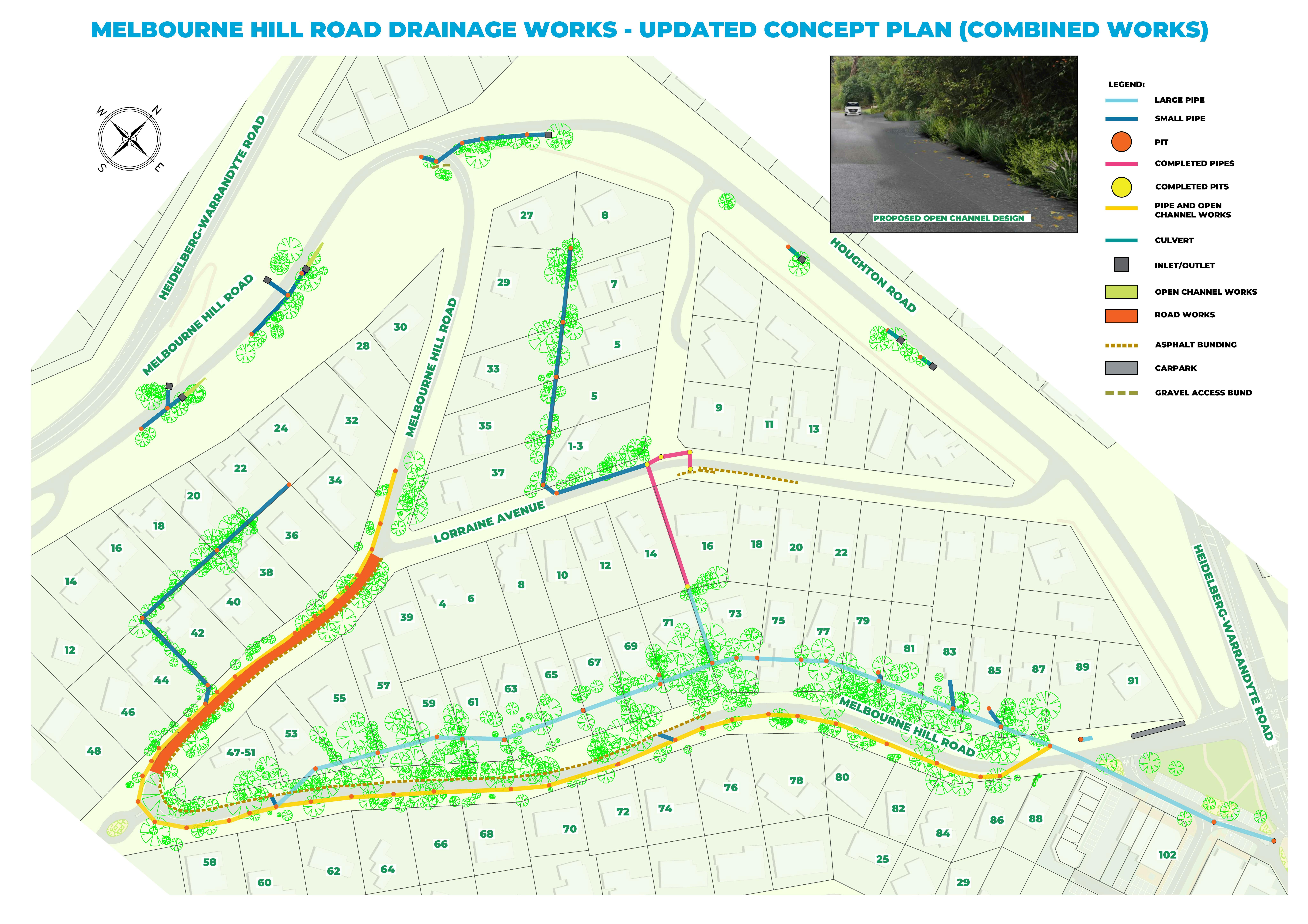
We’re upgrading the drainage system along Melbourne Hill Road to reduce the risks of stormwater flooding to properties in the area.
Where is it?
The project area is along Melbourne Hill Road as well as sections of Houghton Road, Francis Street and Lorraine Avenue. The project covers approximately 35 hectares of residential area.
Why is the upgrade needed?
The project originated in response to a severe flooding event in 2011 that impacted residential and commercial properties in the area. The upgraded drainage system will better direct stormwater into underground drains and reduce the risk of future flooding events in theContinue reading
We’re upgrading the drainage system along Melbourne Hill Road to reduce the risks of stormwater flooding to properties in the area.
Where is it?
The project area is along Melbourne Hill Road as well as sections of Houghton Road, Francis Street and Lorraine Avenue. The project covers approximately 35 hectares of residential area.
Why is the upgrade needed?
The project originated in response to a severe flooding event in 2011 that impacted residential and commercial properties in the area. The upgraded drainage system will better direct stormwater into underground drains and reduce the risk of future flooding events in the area.
The concept for the upgrade aims to:
- Improve flood protection for private dwellings.
- Reduce the risk of uncontrolled water flows by diverting them to underground drains.
- Improve pedestrian safety by reducing surface water flow.
- Minimise the number of properties directly affected by the works.
- Minimise any potential impact on existing structures
- Increase road safety where possible and maintain current roadside parking.
- Preserve the green wedge aesthetic of the area.
- Retain the peri-urban feel of the area by minimising the visual impacts of the works.
- Minimise tree loss and replant with semi-mature stock where possible. A planning permit will be obtained for any tree removal.
The proposed concept design also considers a completed Land Survey, Arborist Report and an Underground Services Investigation.
When will it happen?
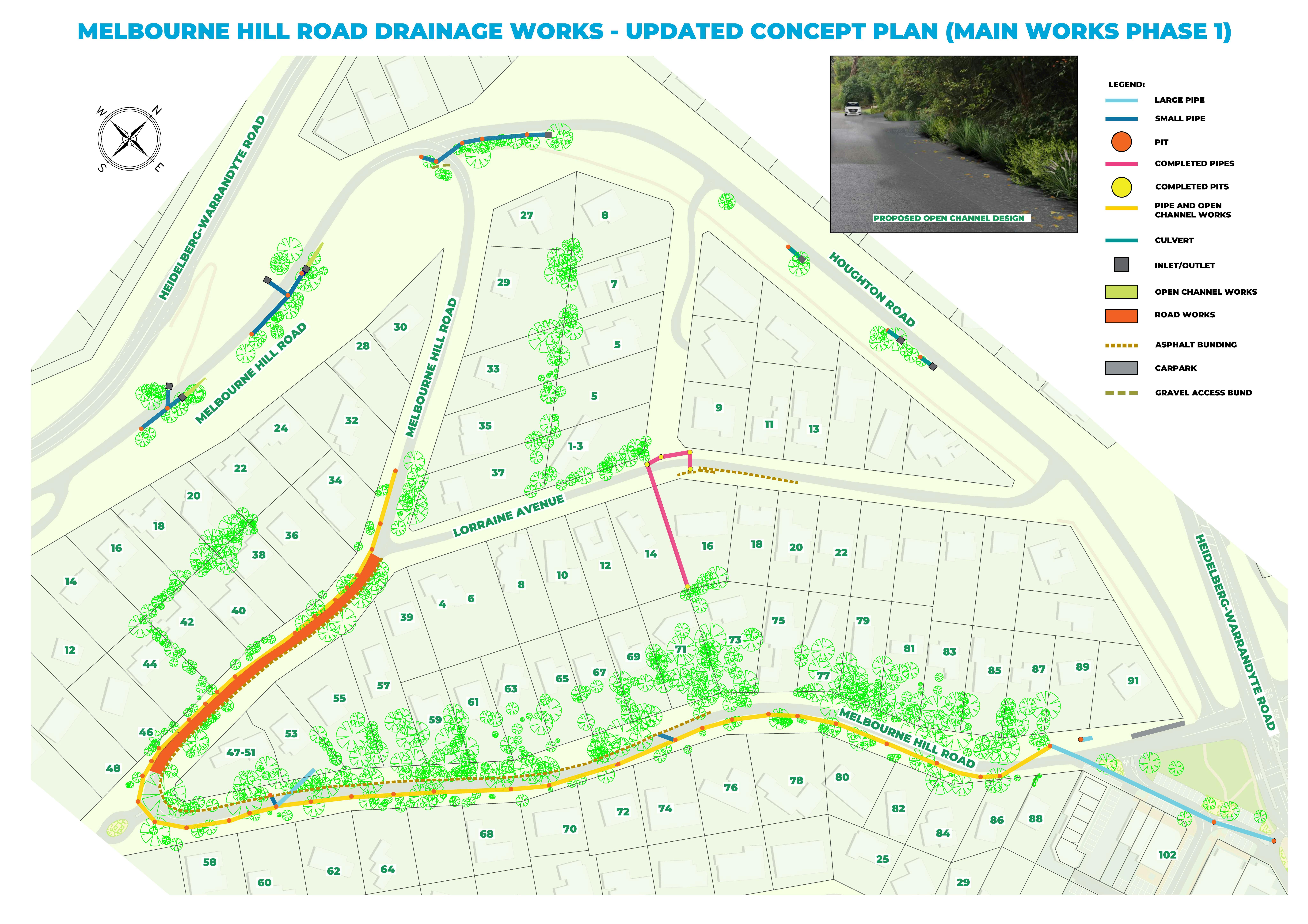
Construction for Main Works - Phase one began in June 2023 and is now completed.
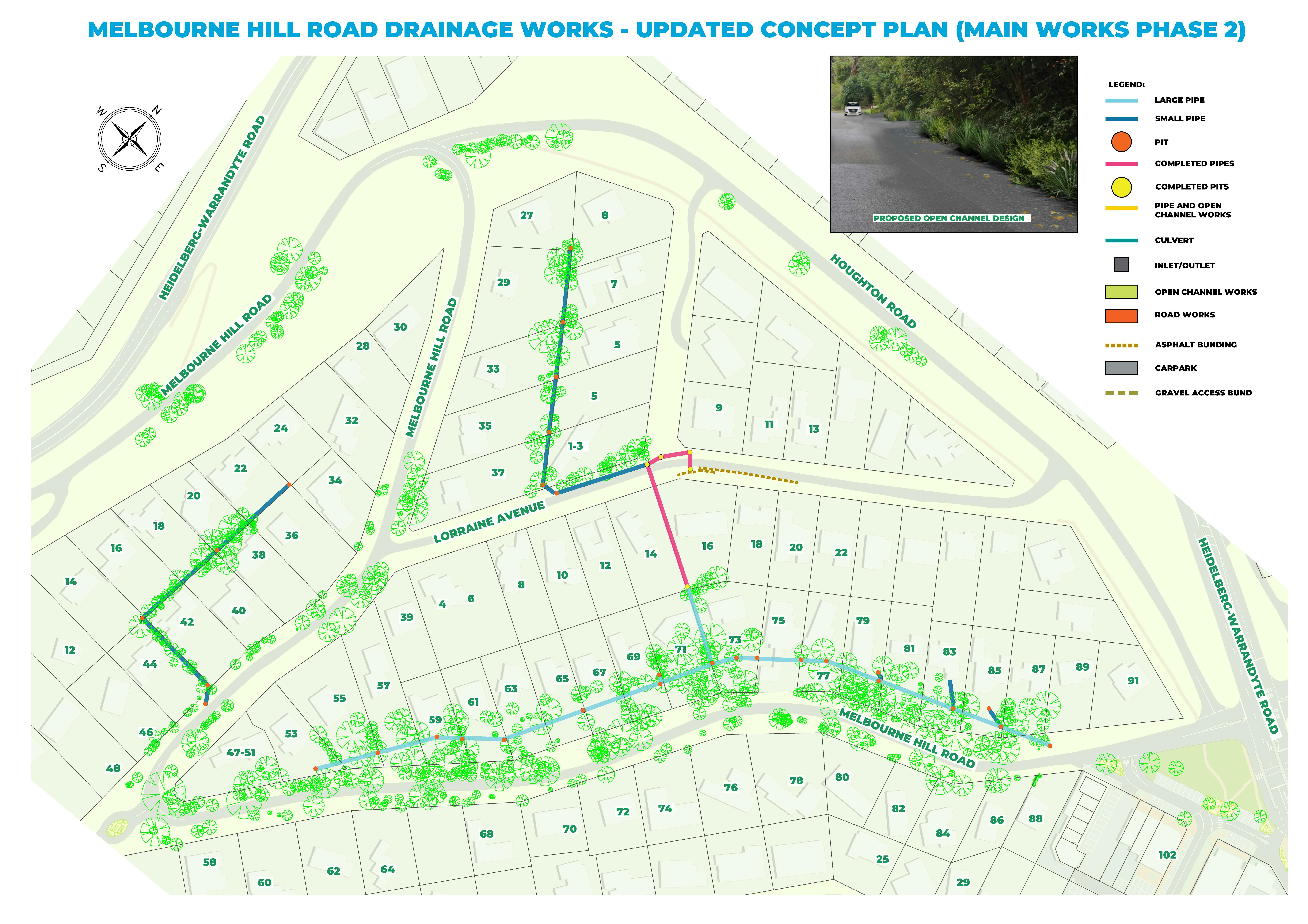
Construction for Main Works - Phase two is expected to begin in late 2025 or early 2026.
Questions?
Ask us through our online Feedback Form
Call us at (03) 9840 9333
Email us at manningham@manningham.vic.gov.au
-
Have your say on environmental weed removal works
Share Have your say on environmental weed removal works on Facebook Share Have your say on environmental weed removal works on Twitter Share Have your say on environmental weed removal works on Linkedin Email Have your say on environmental weed removal works linkBy late April, we’ll appoint contractor to remove the 12 trees (and environmental weeds) from the road reserve. The removal works will begin in early May and are expected to take 1-2 weeks (weather permitting).
If you would like more details, please join us for a face-to-face information session on Thursday 27 April 2023 from 11am to 12pm at the park in front of 100 Melbourne Hill Road, Warrandyte. During this session, we will further explain the process, reason, and outcome of the weed removal (including shrubs and small trees identified as environmental weeds) works.
Follow below link for more information about Environmental Weeds:
-
Project Update April 2023
Share Project Update April 2023 on Facebook Share Project Update April 2023 on Twitter Share Project Update April 2023 on Linkedin Email Project Update April 2023 link
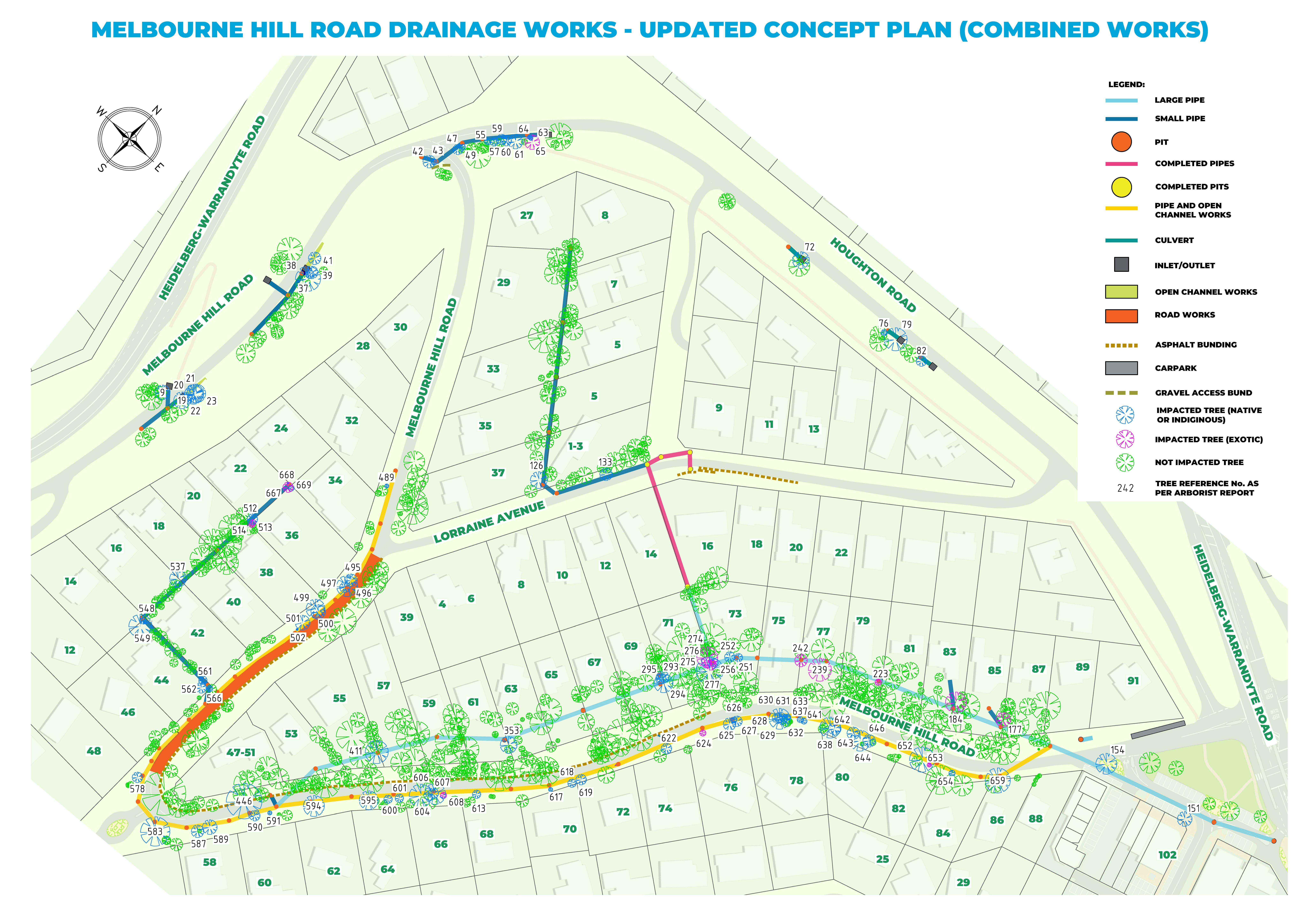
Following our communications in 27 September 2022, we’ve obtained a permit to remove 11 native trees. These trees are highly impacted due to their proximity to the drainage works and, in some cases, because they are in poor health.
Under the dangerous tree exemption rules, we will remove an additional Swamp Gum due to its poor health condition.
Environmental weeds removal will also take place along Melbourne Hill and Houghton roads as part of these works. This will improve conditions for locally indigenous flora species (including new and established trees) to grow naturally within the immediate environment. It will also benefit indigenous flora by opening up the canopy layer spaces and reducing competition for light. Additionally, these works will reduce exotic leaf litter contributing to the suppression of native species and future spread of weeds.
Please see the attached map for the environmental weeds clearance area.
The table below outlines characteristics of the 12 native trees to be removed.
No of trees
Indigenous
Dead
Early Mature
3
Semi Mature
7
1
Mature
1
Community Feedback
We are highly appreciative of your participation in the community information session and the feedback received. We’ve now responded to all of your feedback.
We’d like to emphasise that in developing the design, we have worked with a professional and qualified arborist to assess the impacts on vegetation in line with the Australian standards. A tree management plan has been prepared and will be implemented during the works. It is our intention that the pipes near the trees are installed using root sympathetic techniques, to reduce impacts on the trees.
We will only remove trees in unavoidable situations.
What’s next?
By late April, we’ll appoint contractor to remove the 12 trees (and environmental weeds) from the road reserve. The removal works will begin in early May and are expected to take 1-2 weeks (weather permitting).
When the drainage construction works are completed, we’ll revegetate the road reserve with local, indigenous species.
We’ll make every effort to reduce inconvenience to community during the removal of vegetation.
If you would like more details, please join us for a face-to-face information session on Thursday 27 April 2023 from 11am to 12pm at the park in front of 100 Melbourne Hill Road, Warrandyte. During this session, we will further explain the process, reason, and outcome of the weed removal (including shrubs and small trees identified as environmental weeds) works.
Follow below link for more information about Environmental Weeds:
www.manningham.vic.gov.au/protecting-our-environment/protecting-plants-and-ecology#environmental_weeds_and_pest_plants -
Project Update December 2022
Share Project Update December 2022 on Facebook Share Project Update December 2022 on Twitter Share Project Update December 2022 on Linkedin Email Project Update December 2022 linkWe will begin construction on the Main Works Phase One of the project in early 2023. Phase One includes the construction of underground pits and pipes, open channel, bunding and driveways within the road reserve.
Tenders are now being invited for the construction of Phase One Works and a planning permit for tree removal has been lodged.
During construction there may be some disruptions to traffic flow along Melbourne Hill Road. Appropriate detour signage and traffic management will be in place to assist with traffic flow and every effort will be made to reduce any inconvenience during the progress of these works.
-
Have your say on the proposed updated concept design
Share Have your say on the proposed updated concept design on Facebook Share Have your say on the proposed updated concept design on Twitter Share Have your say on the proposed updated concept design on Linkedin Email Have your say on the proposed updated concept design linkWe’ve now developed updated concept design which aims to:
- Improve flood protection for private dwellings.
- Reduce the risk of uncontrolled water flows by diverting them to underground drains.
- Improve pedestrian safety by reducing surface water flow.
- Minimise the number of properties directly affected by the works.
- Minimise any potential impact to existing structures.
- Increase road safety where possible and maintain current roadside parking.
- Preserve the green wedge aesthetic of the area.
- Retain the peri urban feel of the area by minimising the visual impacts of the works.
- Minimise tree loss and replant with semi mature stock where possible. A planning permit will be obtained for any tree removal.
The concept design also takes into consideration a completed Land Survey, Arborist Report and an Underground Services Investigation. We're in process of completing a Geotechnical Investigation and detailed design.
Will the new drainage system affect my property?
Some sections of the new drainage system overlap with easements on private property. If your property is impacted, we will contact you directly via mail with detailed information on the next step.What’s next?
Feedback on the updated proposed design concept is open until 4.00pm Wednesday 28 September 2022. You can provide feedback using the survey tool on this page.Alternatively, you can join us for a face to face information session on:
- 7 September 2022 from 5.00pm to 6.30pm at Warrandyte Community Hall, 8 Taroona Avenue, Warrandyte.
- 21 September 2022 from 5.00pm to 6.30pm at Warrandyte Community Hall, 8 Taroona Avenue, Warrandyte.
-
Project Update Feb 2022
Share Project Update Feb 2022 on Facebook Share Project Update Feb 2022 on Twitter Share Project Update Feb 2022 on Linkedin Email Project Update Feb 2022 linkManningham is at the final stage of completing the concept design for the proposed drainage. We will be contacting all residents to provide them the opportunity to give their feedback on the concept design plan.
We are still progressing with the land survey, arborist, underground services and geotechnical investigations at the site and once these assessments have been completed, plans for easement creation will be prepared and owners of affected properties will receive a copy of the plan with detailed information on next steps.
Kalow Holdings Pty Ltd has been appointed to construct the drainage from the front of 16 Lorraine Avenue and through the easement along 14 & 16 Lorraine Avenue boundary. The drainage works will end at the south corner of 16 Lorraine Avenue and will take 8 weeks.
-
Council adopts alternative drainage improvement plan
Share Council adopts alternative drainage improvement plan on Facebook Share Council adopts alternative drainage improvement plan on Twitter Share Council adopts alternative drainage improvement plan on Linkedin Email Council adopts alternative drainage improvement plan linkCouncil resolved to adopt an alternative drainage improvement option for the Melbourne Hill Road Drainage Upgrade on 25 February 2020.
Detailed design for the Melbourne Hill Road Drainage Upgrade project will resume shortly.
To construct this drainage project, some additional private property easements will be required.
To inform this, independent consultants, including arborists, surveyors and land valuers, will be assessing sections of the road and catchment to help inform the design and easement requirements.
Once these assessments have been completed, plans for easement creation will be prepared and owners of affected properties will receive a copy of the plan and detailed information.
Follow Project
Project lifecycle
-
Flooding occurred along Melbourne Hill Road
Melbourne Hill Road drainage upgrade has finished this stageDecember 2011
-
Engagement on drainage options
Melbourne Hill Road drainage upgrade has finished this stage2014 and 2015
-
Drainage option endorsed by Council
Melbourne Hill Road drainage upgrade has finished this stageNovember 2015
-
Proposed special charge scheme discontinued by Council
Melbourne Hill Road drainage upgrade has finished this stageDecember 2020
-
Concept drainage design adopted by Council
Melbourne Hill Road drainage upgrade has finished this stage25 February 2020
-
Site investigation and further design work
Melbourne Hill Road drainage upgrade has finished this stage2020 to 2022
-
Consultation on proposed updated concept design
Melbourne Hill Road drainage upgrade has finished this stageAugust to September 2022
-
Detailed Design finalisation
Melbourne Hill Road drainage upgrade has finished this stageLate 2022
-
Planning permit process for phase one
Melbourne Hill Road drainage upgrade has finished this stageEarly 2023
-
Main works construction phase one
Melbourne Hill Road drainage upgrade has finished this stageJune 2023 to May 2024
-
Planning permit process phase two
Melbourne Hill Road drainage upgrade is currently at this stage -
Main works construction phase two
this is an upcoming stage for Melbourne Hill Road drainage upgrade2025
Photos
FAQs
- What is the Melbourne Hill Road drainage upgrade?
- Why is the upgrade needed?
- What are the construction stages?
- Will Council connect private property drains to the new drainage system?
- Is asset reinstatement included in the works?
- How will you minimise any impacts to trees?
- Will there be any road closures during the works?
- What is an easement?
- What is the process for easement acquisition?
- Is my property affected by easement acquisition?
- Why is there a need to create a new easement when my property already has one?
- How is the project being funded?
Document Library
Custom

Who's Listening
-
S
Phone 9840 9333 Email manningham.manningham@manningham.vic.gov


